Girolata, Corsica
Girolata Anchorage
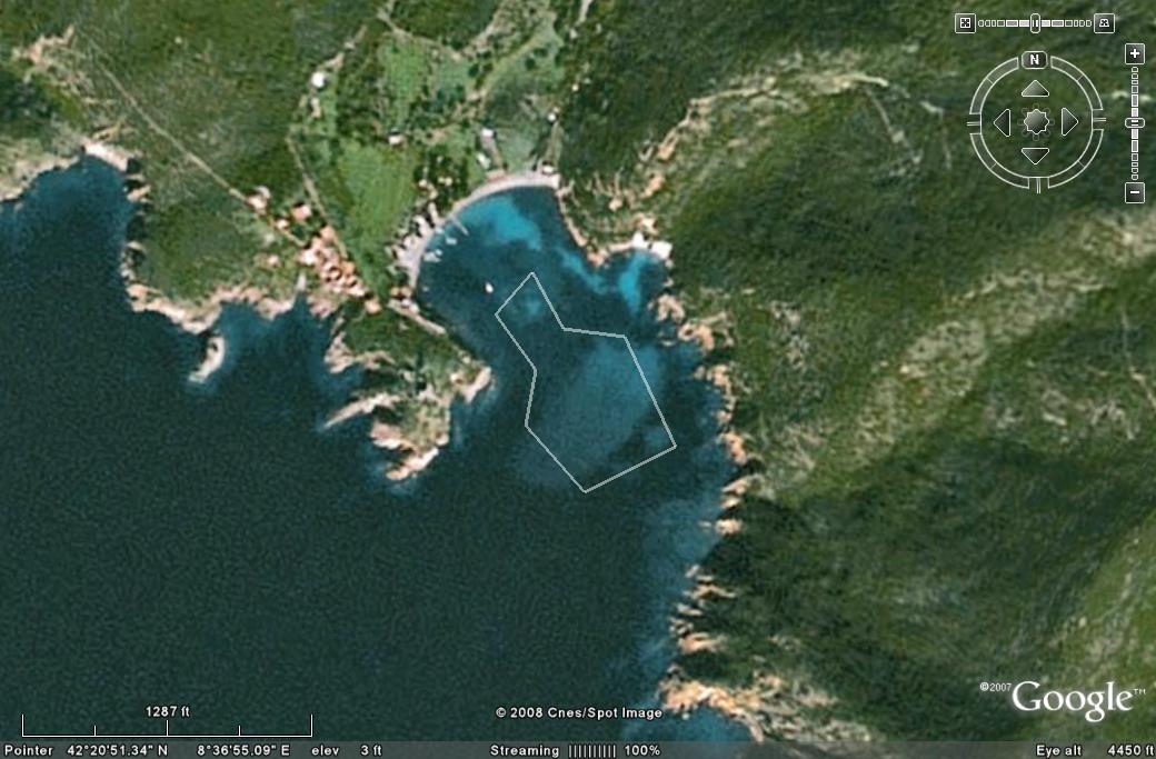
Not to be used for navigation
MOORING FIELD MARKED.
Note: As we were leaving in early May, more moorings were being added between the existing moorings and the two yellow
entrance buoys. In the above picture the area to the right of the catamaran is all shallow and the moorings in that part of the bay
only usable by shallow draft vessels.
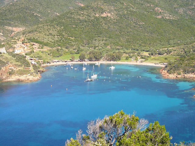
DIRECTIONS
There are rocks either side of the small bay, the entrance is marked with two yellow buoys. Go between them. There is a large shallow area marked on the chart which has depths of less than 6'6". The local capitanerie met us at the entrance to the small bay, asked our draught and asked us to follow him to the mooring. He then led us hard aground on this shallow area! It has a mud bottom and we eased off after a while. In the summer the entire bay is filled with mooring balls. We were here in early May and they were busy putting out more mooring balls as we left. The mooring balls are set very close together. This could be a concern in a blow. Charges for a 49' yacht on the mooring balls range from €24 a night off season (09/20 - 06/01) which we paid, to €33 mid season (06/01-07/06 & 08/25-09/20), and €40 high season (07/07-08/24). If you would prefer to anchor, check out Taura Beach Anchorage just a mile or so away.DESCRIPTION
The bay is well sheltered from the prevailing westerlies. It can get rough in a libeccio. As noted above the entire bay is shallow, mainly 8' or less. The capitanerie will direct you to a buoy depending on your draft/length. I would try and get a buoy close to the entrance to the bay as the moorings are so close together as to make it difficult to leave if the wind came up while the moorings were filled with boats.GETTING ASHORE
There are three short wooden piers. One is reserved for the local boats, the second is used by the ferries during the day and can be used by shallow draft boats at night (an Ovni tied up there while we were in the bay). Dinghies can use this pier day or evening if you tie up at the shoreline and well away from the ferry docking area.ASHORE
Girolata is a small commune with about a dozen houses built from the local red/orange stone. We were told that access is not permitted to the attractive Genoese fort that marks the headland. The residents have no road access and live off the tourist trade. Our guide book describes Girolata thus: "Private yachts carrying the kind of people who frequent end-of-the-world beaches pull in at the superb harbour, as do a flotilla of sightseeing boats from nearby Porto and other coastal resorts."There are several spectacular shorter half-day hikes that start from Girolata. We took the Chemin de facteur" (Postman's trail) to Taura beach, and returned to Girolata on a different trail (clearly marked at Taura beach). This hike is about 2-3 hours (not counting a stop at the beach) and has a number of steep sections as well as some scree (loose rock). Not a beginner's hike but not too difficult and very rewarding with spectacular views over the bays and down into the valley.
FACILITIES ASHORE
The small commune serves the numerous ferries that drop their tourists off for an hour or so and there are three or four restaurants, a bar and a tiny general store as well as the capitanerie office.The capitanerie sells wifi access for €1 per hour, or €5 for the night. Girolata is also on the Mare e Monti Nord trail (10 day-long stages) and has two gites d'etape (hikers lodges) offering basic accommodation and food to hikers.